Arnab
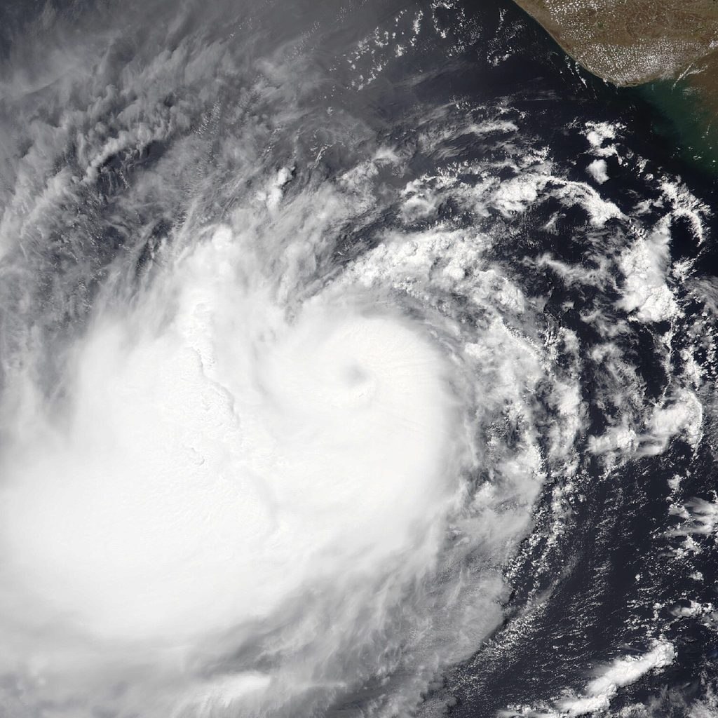
Overview
Cyclone Arnab (IMD designation BOB/08/2026) formed as a Depression over the eastcentral and adjoining southeast Bay of Bengal on 25 October 2026. It intensified into a Deep Depression and then Cyclonic Storm Arnab, and on the night of 26 October became a Very Severe Cyclonic Storm over the westcentral Bay of Bengal. It crossed the Andhra Pradesh and Yanam coasts southwest of Yanam, about 20 km east-northeast of Narsapur, early on 28 October as a Very Severe Cyclonic Storm with maximum sustained winds of 125-135 km/h gusting to 150 km/h, and weakened into a Severe Cyclonic Storm over land that morning. Moving north-northwest and then north into south Chhattisgarh, it weakened into a Deep Depression late on 28 October and a Depression by the morning of 29 October, bringing extremely heavy rain to south Odisha. Its remnant weakened into a well-marked low pressure area over central Chhattisgarh later on 29 October and into a low pressure area over north Chhattisgarh and adjoining East Madhya Pradesh by the morning of 30 October, after bringing up to 280 mm of rain to Kusmi in Balrampur district, Chhattisgarh. The rain caused river flooding in Gajapati district, where the Mahendratanaya overflowed into villages in Goshani block and a bridge collapsed in Mohana block, pushed the Vamsadhara above its danger mark, and swelled rivers flowing into Chhattisgarh. In Andhra Pradesh about 2.24 lakh hectares of crops, mostly paddy in the Godavari delta districts, were inundated or damaged. At least five deaths were reported in Andhra Pradesh, along with widespread damage to trees, power lines, roads, houses and crops. The name Arnab was proposed by Bangladesh.
Timeline
Affected Areas
Key Statistics
IMD District Warnings
Valid from 8:30 am IST on 28 October to 8:30 am IST on 29 October, as Arnab moved inland across south Odisha.
Source: IMD press release no. 6 (28 October 2026): Meteorological Centre Amaravati's Andhra Pradesh map (issued 27 October) and Meteorological Centre Bhubaneswar's Odisha map (issued 28 October)
Rainfall Recorded
Each figure is the rain measured at that place over about one day. Pick a day to see its exact time window.
Arnab came ashore southwest of Yanam, near Narsapur (West Godavari), early on 28 October. The heaviest rain fell far to the north of the landfall point, over north coastal Andhra Pradesh and then south Odisha.
Odisha
Highest 546 mm · 7 places- PatrapurGanjam district · 29 Oct546 mmExtremely heavy
- SoradaGanjam district · 29 Oct503 mmExtremely heavy
- G. UdayagiriKandhamal district · 29 Oct462 mmExtremely heavy
- MahendragarhGajapati district · 29 Oct458 mmExtremely heavy
- SanakhemundiGanjam district · 29 Oct388 mmExtremely heavy
- ChikitiGanjam district · 29 Oct309 mmExtremely heavy
- BhograiBalasore district · 30 Oct190 mmVery heavyReported by IMD as 19 cm
Chhattisgarh
Highest 280 mm · 2 places- KusmiBalrampur district · 30 Oct280 mmExtremely heavyReported by IMD as 28 cm
- Sukma30 Oct70 mmHeavyReported by IMD as 7 cm
Andhra Pradesh
Highest 261.5 mm · 14 places- KannuripalemAnakapalli district · 28 Oct261.5 mmExtremely heavyWindow ends 4 am IST, 28 Oct
- Vizianagaram (KVBR School)Vizianagaram district · 28 Oct259.7 mmExtremely heavyWindow ends 4 am IST, 28 Oct
- Visakhapatnam (16th Bn area)Visakhapatnam district · 28 Oct259.1 mmExtremely heavyWindow ends 4 am IST, 28 Oct
- IchchapuramSrikakulam district · 29 Oct240 mmExtremely heavyReported by IMD as 24 cm
- SompetaSrikakulam district · 29 Oct220 mmExtremely heavyReported by IMD as 22 cm
- Visakhapatnam28 Oct216.9 mmExtremely heavy
- KalingapatnamSrikakulam district · 28 Oct147.5 mmVery heavy
- TuniKakinada district · 28 Oct123.3 mmVery heavy
- KakinadaLandfall area28 Oct118.4 mmVery heavy
- MachilipatnamKrishna district · 28 Oct115.2 mmHeavy
- Srikakulam30 Oct80 mmHeavyReported by IMD as 8 cm
- NarsapurLandfall areaWest Godavari district · 28 Oct48.6 mmModerate
- Bapatla28 Oct15.9 mmModerate
- OngolePrakasam district · 28 Oct0.4 mmLight
West Bengal
Highest 80 mm · 1 place- DighaPurba Medinipur district · 30 Oct80 mmHeavyReported by IMD as 8 cm
Jharkhand
Highest 80 mm · 1 place- DaltonganjPalamu district · 30 Oct80 mmHeavyReported by IMD as 8 cm
What the numbers mean
1 mm of rain is 1 litre of water on every square metre of ground. IMD grades a day’s rain like this:
- Extremely heavy204.5 mm or moreRivers can flood within hours; landslides likely in hilly areas.
- Very heavy115.6–204.4 mmWaterlogging, overflowing streams and disrupted roads are likely.
- Heavy64.5–115.5 mmWaterlogging in low-lying areas and slow traffic.
- Moderate15.6–64.4 mmA steady rainy day.
Source: IMD station observations, as reported by the press on 28-29 October 2026 (India.com, Dynamite News, The Daily Pioneer, Business Today), and IMD's press release of 30 October 2026. Provisional until IMD publishes its final report.