Murasu · Severe Cyclonic Storm · landfall: Andhra Pradesh · updated 3 November 2026 at 01:30 pm
LIVEMonitoring: Murasu

DECODING THE
STORM

Your independent source for cyclone analysis in the Indian Ocean, Bay of Bengal & Arabian Sea. We provide simplified tracking, historical records, and real-time satellite interpretation.

260KM/H
Highest wind speed on recordOdisha Super Cyclone · 1999Sustained (IMD) · record gust 300 km/h
LIVE|Murasu(Severe Cyclonic Storm)
Location:South coastal Andhra Pradesh, west of Bapatla
Wind:110 km/h
Pressure:996 hPa

Live storm details

MurasuSevere Cyclonic Storm

As of IMD’s update of 3 Nov, 1:30 pm IST

Full tracking →
Sustained wind
85-95 km/h
Gusting to 105 km/h
Central pressure
996 hPa
IMD estimate
Moving
North-northwest
at 6 km/h
Position
15.9°N, 80.1°E
South coastal Andhra Pradesh, west of Bapatla
Landfall
3 Nov, 4:30 am IST
South Andhra Pradesh coast, between Nellore and Narsapur, close to Ongole

Intensity journey

  1. DepressionFirst reported · 31 Oct, 11:30 am IST
  2. Cyclonic StormFirst reported · 1 Nov, 2:30 pm IST
  3. Severe Cyclonic StormFirst reported · 2 Nov, 2:30 am IST
  4. Landfall: South Andhra Pradesh coast, between Nellore and Narsapur, close to OngoleObserved · 3 Nov, 4:30 am IST
  5. Severe Cyclonic StormNow · 3 Nov, 11:30 am IST
  6. Cyclonic StormForecast · 3 Nov, 5:30 pm IST
  7. Deep DepressionForecast · 3 Nov, 11:30 pm IST
  8. DepressionForecast · 4 Nov, 5:30 am IST

Past stages are dated by the first IMD position reported at that strength.

IMD forecast

TimePositionWind (km/h)Stage
Now15.9°N, 80.1°E85-95 g105Severe Cyclonic Storm
3 Nov, 5:30 pm16.2°N, 80.0°E65-75 g85Cyclonic Storm
3 Nov, 11:30 pm16.5°N, 80.0°E55-65 g75Deep Depression
4 Nov, 5:30 am16.8°N, 80.0°E40-50 g60Depression

Times in IST. “g” = gusts.

Hazards

WindRed warning

Gale winds of 85-95 km/h gusting to 105 km/h over Krishna, Bapatla, Prakasam, SPSR Nellore, Guntur, Eluru, NTR, Palnadu and West Godavari districts, easing to 65-75 km/h by the evening of 3 November and 55-65 km/h by midnight. 65-75 km/h gusting to 85 over ten east Telangana districts (including Khammam, Suryapet, Nalgonda and Warangal) and Chittoor-Tirupati until the afternoon of 3 November; 50-60 km/h gusting to 70 over the south Odisha coast and north Tamil Nadu-Puducherry until that afternoon or evening.

Rain

Heavy to very heavy rain with isolated extremely heavy falls over coastal Andhra Pradesh and east Telangana on 3 November, and isolated heavy to very heavy rain over coastal Andhra Pradesh on 4 November. Isolated heavy rain over Rayalaseema, north Tamil Nadu and south Odisha on 3 November and Chhattisgarh on 3-4 November. Moderate flash flood risk until 1130 IST on 4 November over Prakasam, Palnadu, Bapatla, Guntur, Krishna, NTR, Eluru, East and West Godavari, Konaseema and Kakinada districts.

Sea & fishermen

Very high to high seas over the westcentral Bay of Bengal and along and off the Andhra Pradesh coast until the evening of 3 November, becoming very rough to rough by the morning of 4 November. Fishermen should not go out there until the morning of 4 November, or into the southwest Bay of Bengal, off north Tamil Nadu-Puducherry, the adjoining northwest Bay of Bengal or off south Odisha until the evening of 3 November.

Storm surge

IMD warned of a peak surge of 1.0-1.5 m above the astronomical tide over Bapatla, Krishna and Prakasam districts around landfall, easing to 0.5-1.0 m by the morning of 3 November and subsiding after noon. Its 1130 IST advisory no longer carries a storm surge warning.

Where It Rained

State and place-wise rainfall from Murasu, in mm

Live Tracking →

Murasu: Rainfall So Far

Each figure is the rain measured at that place over about one day. Pick a day to see its exact time window.

Murasu came ashore close to Ongole (Prakasam), about 40 km southwest of Bapatla, between 0330 and 0530 IST on 3 November. The heaviest rain fell at Bapatla, just northeast of the landfall point, and further up the coast in West Godavari district.

Wettest place
220 mm
Bapatla, Andhra Pradesh · 3 Nov
Places reporting
17
1 with extremely heavy rain
States
3
Andhra Pradesh, Tamil Nadu, Puducherry

Andhra Pradesh

Highest 220 mm · 14 places
  • BapatlaLandfall area3 Nov
    220 mmExtremely heavy
    Reported by IMD as 22 cm
  • NarsapuramWest Godavari district · 3 Nov
    200 mmVery heavy
    Reported by IMD as 20 cm
  • KaramcheduBapatla district · 3 Nov
    160 mmVery heavy
    Reported by IMD as 16 cm
  • AddankiBapatla district · 3 Nov
    150 mmVery heavy
    Reported by IMD as 15 cm
  • BheemavaramWest Godavari district · 3 Nov
    130 mmVery heavy
    Reported by IMD as 13 cm
  • OngoleLandfall areaPrakasam district · 3 Nov
    120 mmVery heavy
    Reported by IMD as 12 cm
  • RacherlaPrakasam district · 3 Nov
    120 mmVery heavy
    Reported by IMD as 12 cm
  • PalakoderuWest Godavari district · 3 Nov
    120 mmVery heavy
    Reported by IMD as 12 cm
  • BestavaripetaPrakasam district · 3 Nov
    110 mmHeavy
    Reported by IMD as 11 cm
  • SeetharamapuramSPSR Nellore district · 3 Nov
    110 mmHeavy
    Reported by IMD as 11 cm
  • AvanigadaKrishna district · 3 Nov
    80 mmHeavy
    Reported by IMD as 8 cm
  • Masulipatnam CDRKrishna district · 3 Nov
    80 mmHeavy
    Reported by IMD as 8 cm, at the Machilipatnam cyclone detection radar station
  • SanthamaguluruBapatla district · 3 Nov
    70 mmHeavy
    Reported by IMD as 7 cm
  • RepalleBapatla district · 3 Nov
    70 mmHeavy
    Reported by IMD as 7 cm

Tamil Nadu

Highest 150 mm · 2 places
  • Kadapakkam2 Nov
    150 mmVery heavy
    Reported by IMD as 15 cm, with no district
  • Cuddalore3 Nov
    90 mmHeavy
    Reported by IMD as 9 cm

Puducherry

Highest 70 mm · 1 place
  • Puducherry3 Nov
    70 mmHeavy
    Reported by IMD as 7 cm, at each of two Puducherry stations

What the numbers mean

1 mm of rain is 1 litre of water on every square metre of ground. IMD grades a day’s rain like this:

  • Extremely heavy204.5 mm or moreRivers can flood within hours; landslides likely in hilly areas.
  • Very heavy115.6–204.4 mmWaterlogging, overflowing streams and disrupted roads are likely.
  • Heavy64.5–115.5 mmWaterlogging in low-lying areas and slow traffic.
  • Moderate15.6–64.4 mmA steady rainy day.

Source: IMD station observations: IMD national bulletin no. 22 (Annexure-1) and mid-day all-India weather bulletin of 3 November 2026, and IMD press release of 2 November 2026. IMD lists only stations with 7 cm or more. Provisional until IMD publishes its final report.

EXTREMELY RARE

Super Cyclones

4 storms in our archive crossed the Super Cyclonic Storm mark (≥222 km/h sustained). 3 more came within 15 km/h of it.

1999
Odisha Super Cyclone
2007
Gonu
2019
Kyarr
2020
Amphan
4
Crossed 222 km/h
Super Cyclonic Storms
3
Just short
Within 15 km/h
2
Bay of Bengal
Super cyclones
2
Arabian Sea
Super cyclones
260
Strongest (km/h)
Odisha Super Cyclone 1999

Highest Wind Speed Ever Recorded

The strongest cyclone in our archive, measured by IMD sustained winds (3-minute average).

Latest Bulletins

Recent analysis and updates from our team

View All Bulletins →

Cyclone Archives

Explore historical cyclones in the Indian Ocean region

Browse Archives →
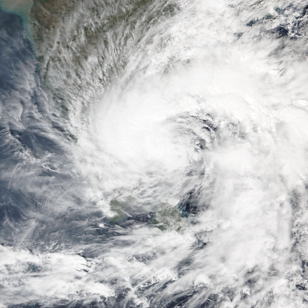
Murasu satellite imagery
Severe Cyclonic Storm

Murasu

2026
Max Wind110 km/h
Gusts120 km/h
DurationOngoing
BasinBay of Bengal
LandfallSouth Andhra Pradesh coast between Nellore and Narsapur, close to Ongole (near 15.53°N, 80.22°E, about 40 km southwest of Bapatla)

Cyclone Murasu, the ninth Bay of Bengal system of 2026 (BOB 09), formed as a Depression over the southeast Bay of Bengal at 1130 IST on 31 October 2026 near 10.0°N, 90.2°E, about 330 km west-southwest of Sri Vijayapuram. Moving west-northwestwards, it intensified into a Deep Depression and then Cyclonic Storm Murasu on 1 November, and into a Severe Cyclonic Storm over the westcentral Bay of Bengal on 2 November. Slowing to 8-9 km/h as it neared land, it crossed the south Andhra Pradesh coast between Nellore and Narsapur, close to Ongole (near 15.5°N, 80.2°E), between 0330 and 0530 IST on 3 November as a Severe Cyclonic Storm, with maximum sustained winds of 100-110 km/h gusting to 120 km/h, an estimated central pressure of about 995 hPa and IMD warning of a 1.0-1.5 m storm surge over Bapatla, Krishna and Prakasam districts. Bapatla recorded 22 cm of rain in the 24 hours to 0830 IST on 3 November. Over land it moved slowly north-northwestwards and was still a Severe Cyclonic Storm 40 km west of Bapatla at 1130 IST on 3 November; IMD forecasts it to weaken into a Cyclonic Storm that afternoon, a Deep Depression around midnight and a Depression by the morning of 4 November. The name Murasu was proposed by India and means "drum" in Tamil.

Andaman & Nicobar IslandsAndhra PradeshYanam (Puducherry)+3
Arnab satellite imagery
Very Severe Cyclonic Storm

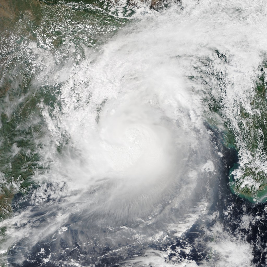
Arnab

2026
Max Wind135 km/h
Gusts150 km/h
Duration5 days
BasinBay of Bengal
LandfallAndhra Pradesh & Yanam coast, southwest of Yanam (about 20 km ENE of Narsapur, 60 km SW of Kakinada)

Cyclone Arnab (IMD designation BOB/08/2026) formed as a Depression over the eastcentral and adjoining southeast Bay of Bengal on 25 October 2026. It intensified into a Deep Depression and then Cyclonic Storm Arnab, and on the night of 26 October became a Very Severe Cyclonic Storm over the westcentral Bay of Bengal. It crossed the Andhra Pradesh and Yanam coasts southwest of Yanam, about 20 km east-northeast of Narsapur, early on 28 October as a Very Severe Cyclonic Storm with maximum sustained winds of 125-135 km/h gusting to 150 km/h, and weakened into a Severe Cyclonic Storm over land that morning. Moving north-northwest and then north into south Chhattisgarh, it weakened into a Deep Depression late on 28 October and a Depression by the morning of 29 October, bringing extremely heavy rain to south Odisha. Its remnant weakened into a well-marked low pressure area over central Chhattisgarh later on 29 October and into a low pressure area over north Chhattisgarh and adjoining East Madhya Pradesh by the morning of 30 October, after bringing up to 280 mm of rain to Kusmi in Balrampur district, Chhattisgarh. The rain caused river flooding in Gajapati district, where the Mahendratanaya overflowed into villages in Goshani block and a bridge collapsed in Mohana block, pushed the Vamsadhara above its danger mark, and swelled rivers flowing into Chhattisgarh. In Andhra Pradesh about 2.24 lakh hectares of crops, mostly paddy in the Godavari delta districts, were inundated or damaged. At least five deaths were reported in Andhra Pradesh, along with widespread damage to trees, power lines, roads, houses and crops. The name Arnab was proposed by Bangladesh.

Andhra PradeshYanam (Puducherry)Odisha+4

Cyclone Names

All 169 names on the North Indian Ocean list, given by 13 countries. Each name is used once, in order.

How Names Work →
Used so far28 of 169
Most recentMurasu India
Next nameAkvan Iran
North Indian Ocean cyclone names by country (rows) and list column (1 to 13). Names are used column by column, top to bottom.
Country12345678910111213
BangladeshNisarga (Used)Biparjoy (Used)Arnab (Used)UpakulBarshonRajaniNishithUrmiMeghalaSamironPratikulSaroborMahanisha
IndiaGati (Used)Tej (Used)Murasu (Most recent)AagVyomJharProbahNeerPrabhanjanGhurniAmbudJaladhiVega
IranNivar (Used)Hamoon (Used)Akvan (Next name)SepandBooranAnahitaAzarPooyanArshamHengameSavasTahamtanToofan
MaldivesBurevi (Used)Midhili (Used)KaaniOdiKenauEndheriRiyauGuruvaKurangiKuredhiHoranguThundiFaana
MyanmarTauktae (Used)Michaung (Used)NgamannKyarthitSapakyeeWetwunMwaihoutKywePinkuYinkaungLinyoneKyeekanBautphat
OmanYaas (Used)Remal (Used)SailNaseemMuznSadeemDimaManjourRukamWatadAl-jarzRababRaad
PakistanGulab (Used)Asna (Used)SahabAfshanManahilShujanaParwazZannataSarsarBadbanSarrabGulnarWaseq
QatarShaheen (Used)Dana (Used)LuluMoujSuhailSadafReemRayhanAnbarOudBaharSeefFanar
Saudi ArabiaJawad (Used)Fengal (Used)GhazeerAsifSidrahHareedFaidKaseerNakheelHaboobBareqAlreemWabil
Sri LankaAsani (Used)Shakhti (Used)GigumGaganaVerambhaGarjanaNeebaNinnadaViduliOghaSalithaRiviRudu
ThailandSitrang (Used)Montha (Used)ThianyotBulanPhutalaAiyaraSamingKraisonMatchaMahingsaPhraewaAsuriThara
UAEMandous (Used)Senyar (Used)AfoorNahhaamQuffalDaamanDeemGargoorKhubbDeglAthmadBoomSaffar
YemenMocha (Used)Ditwah (Used)DiksamSiraBakhurGhwyziHawfBalhafBromShuqraFartakDarsahSamhah

Read the list column by column, top to bottom: column 1 from Bangladesh to Yemen, then column 2, and so on. The same list is shared by the Bay of Bengal and the Arabian Sea, and a system is named only when IMD upgrades it to a Cyclonic Storm. Source: WMO.
24
Cyclones Tracked
4
Super Cyclones
2
Ocean Basins
27+
Years of Data